 to
to  in Bourne.
 /
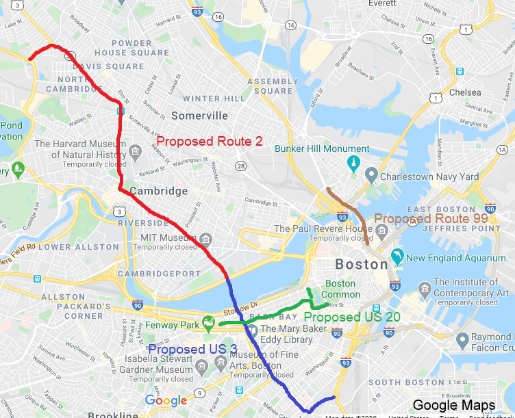
/  due to cancelling of freeway project, takes surface streets between
Burlington and Cambridge. Runs concurrent with
due to cancelling of freeway project, takes surface streets between
Burlington and Cambridge. Runs concurrent with  ,
,  and
and
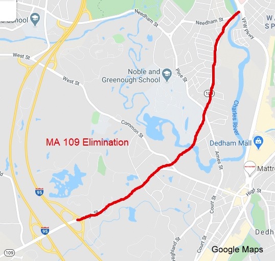
 for portions of its route, ends in Cambridge at .
  . MassDOT already defines it
as one route and continues the mileage of
on . is the failure of Memorial
Drive in Cambridge to meet AASHTO US Route Standards. You could solve
this be rerouting
from its current ending at Mass Ave, having it turn south at Mass Ave
across the Charles River into Boston and ending it at the interchange
with
. MassDOT already defines it
as one route and continues the mileage of
on . is the failure of Memorial
Drive in Cambridge to meet AASHTO US Route Standards. You could solve
this be rerouting
from its current ending at Mass Ave, having it turn south at Mass Ave
across the Charles River into Boston and ending it at the interchange
with  /
/  / .
Then simply change route shields along 's route to .
/ .
Then simply change route shields along 's route to . 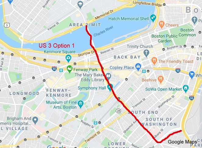 and a freeway by continuing the existing concurrency along / north (east) to and then down South to
Boston where it would pick up the current
route. All you would have to do is change the route shields from there
south to .
(Another possibility is simply ending
at /
in Burlington and redesignating from Braintree to Bourne as
something else, see Suggested New Routes section below).
and a freeway by continuing the existing concurrency along / north (east) to and then down South to
Boston where it would pick up the current
route. All you would have to do is change the route shields from there
south to .
(Another possibility is simply ending
at /
in Burlington and redesignating from Braintree to Bourne as
something else, see Suggested New Routes section below).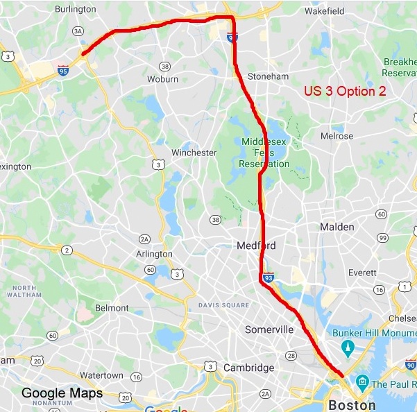

in Kenmore Square. .
.
 East would travel length of
Commonwealth Avenue, take right at Arlington, then left at Boylston and
end at
South at Charles Street at Boston Common.
West would begin at intersection with
South at corner of Beacon and Arlington Streets, and turn right at
Commonwealth.
East would travel length of
Commonwealth Avenue, take right at Arlington, then left at Boylston and
end at
South at Charles Street at Boston Common.
West would begin at intersection with
South at corner of Beacon and Arlington Streets, and turn right at
Commonwealth.

twice. This section is also not signed very well.
North /
East to current East, use 's
routing through Cambridge, end at
at Commonwealth Avenue in Boston (see idea for ). If first rerouting proposal is adopted,
can end at Memorial Drive (see below).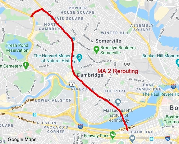

 to Holyoke, then north to NH border.
 was
originally a New England Interstate Route from CT to NH, the routing was put on to it in
1927. The concurrency is unnecessary.
from its concurrency with .
was
originally a New England Interstate Route from CT to NH, the routing was put on to it in
1927. The concurrency is unnecessary.
from its concurrency with .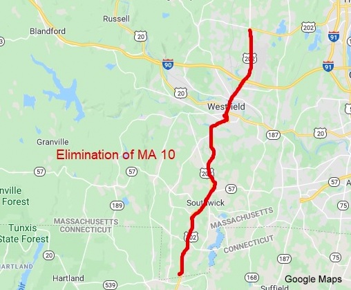

 in Wareham to
at Bourne. .
Is a short route at only 10 miles long.
from Bourne to Orleans.
between Falmouth and Orleans which is signed North/South but is mostly
East/West, would be part of the suggested decommissioning of south of Bridgewater (see
below).
in Wareham to
at Bourne. .
Is a short route at only 10 miles long.
from Bourne to Orleans.
between Falmouth and Orleans which is signed North/South but is mostly
East/West, would be part of the suggested decommissioning of south of Bridgewater (see
below).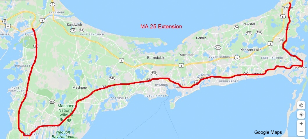

at the Orleans Rotary to the NH Border. is a successor to another one
of the original NE Interstate Routes from the 1920s, designed to take
people from Cape Cod to New Hampshire. The route has been made redundant
since the development of the expressway system since the 1960s. Not many
people would take the route its entire length today, but rather faster
alternative such as and . intersection in Bridgewater. While
serves as a good backup route to
from Boston to New Hampshire, most of the route in and south of Boston
serves local traffic, runs concurrently with other routes, or simply
parallels
from Middleborough to Wareham. to
Middleborough. A new number could be used from in Middleborough to in Wareham, if having a backup
route is important for .
intersection in Bridgewater. While
serves as a good backup route to
from Boston to New Hampshire, most of the route in and south of Boston
serves local traffic, runs concurrently with other routes, or simply
parallels
from Middleborough to Wareham. to
Middleborough. A new number could be used from in Middleborough to in Wareham, if having a backup
route is important for .
 can take over its routing on Cape Cod.
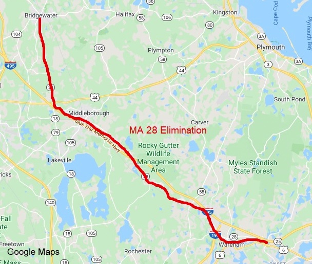
that parallels
is too important not to have a number. One way to solve it would be to
take my
proposal further and extend it west as well as east along the current to
Middleborough. This would require, however, a new number for the current
freeway. The simplest thing to do would be to extend along the route, but even digit
three-digit interstate routes are supposed to end at other interstates,
there are exceptions (like
in NY), this could be another. Or you could extend  along 's
route instead, or make the route east of , MA 495.
along 's
route instead, or make the route east of , MA 495.

, runs concurrently with  along new surface roadway.
 formerly ended at along an elevated expressway along
Fall River's waterfront, thus viaduct was removed in 2016 placing
along surface route with
and having it end suddenly at intersection with a street that leads to
ramps to .
back to new end of expressway at
/ .
signage south of
exit, let
by itself take over new surface street alignment.
formerly ended at along an elevated expressway along
Fall River's waterfront, thus viaduct was removed in 2016 placing
along surface route with
and having it end suddenly at intersection with a street that leads to
ramps to .
back to new end of expressway at
/ .
signage south of
exit, let
by itself take over new surface street alignment.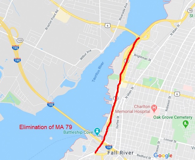

 ,
to
,
to  in Kingston, total of 6.5 miles.
along former
in Plymouth, relabel it as a North-South route.
signage east along Carver Road/Samoset Street 2 miles to .
in Kingston, total of 6.5 miles.
along former
in Plymouth, relabel it as a North-South route.
signage east along Carver Road/Samoset Street 2 miles to .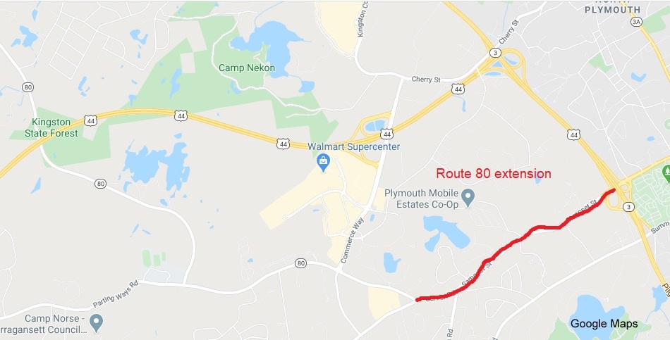

north of . Tunnel. at Haymarket Square, the proposed beginning of
  North:
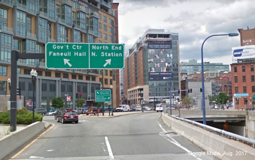 reassurance marker, it is in
Everett, there are none in Boston itself, though it appears on several
overhead signs:
reassurance marker, it is in
Everett, there are none in Boston itself, though it appears on several
overhead signs: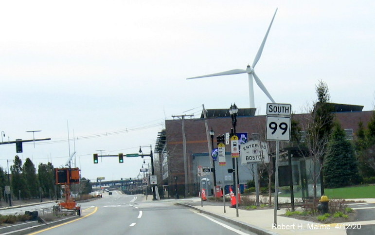

in Milford to former
/VFW Parkway in Dedham.
was taken off its original parkways routing in 1989.
/ .
/ .
 continue to the VFW Parkway and
continue the former
routing to
continue to the VFW Parkway and
continue the former
routing to  ,
or even take over
,
or even take over  (see below) to
in Dorchester. The resulting route though would be quite circuitous. I
find the truncation of a simpler plan.
(see below) to
in Dorchester. The resulting route though would be quite circuitous. I
find the truncation of a simpler plan.

in Canton to  in Gloucester
from Canton to Peabody and is barred from being signed, except with
ground mounted signs, by FHWA regulations. to Cape Ann
signs along
between Canton and Peabody
in Gloucester
from Canton to Peabody and is barred from being signed, except with
ground mounted signs, by FHWA regulations. to Cape Ann
signs along
between Canton and Peabody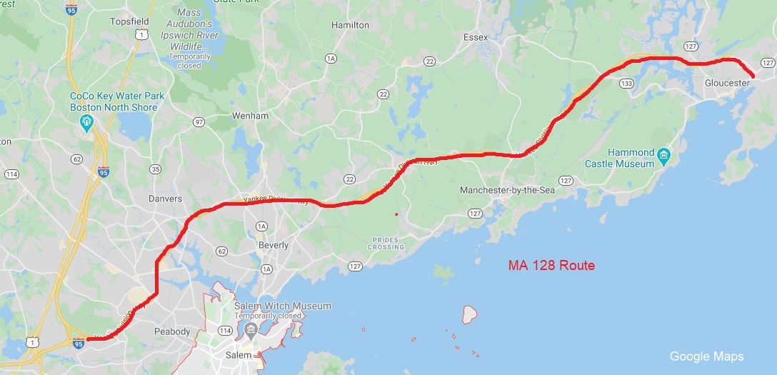 was routed along part of
due to the cancellation of its proposed routing through Boston, has been
trying to remove the
designation south of Peabody, without success due largely to public
sentimentality towards the route. The media and traffic reporters even
today, nearly 50 years later, still mostly refer to from Canton to Peabody (and
often times
between Canton and Braintree) as .
Certainly the cost of maintaining duplicate route signs for along could be better spent
elsewhere. Having it reduced in length, and changed to an East-West
route would seem the most logical way to go. The upcoming exit
renumbering project would have been a perfect time to truncate to simplify the route
numbering in the Boston area, they could blame the FHWA for forcing the
truncation. MassDOT's response though was to just change the numbers
from Peabody to Gloucester based on mileage from Canton responding that
route changes were 'outside the scope of the renumbering project.' This
and the public's attachment to the
route number likely means this change is highly unlikely.
was routed along part of
due to the cancellation of its proposed routing through Boston, has been
trying to remove the
designation south of Peabody, without success due largely to public
sentimentality towards the route. The media and traffic reporters even
today, nearly 50 years later, still mostly refer to from Canton to Peabody (and
often times
between Canton and Braintree) as .
Certainly the cost of maintaining duplicate route signs for along could be better spent
elsewhere. Having it reduced in length, and changed to an East-West
route would seem the most logical way to go. The upcoming exit
renumbering project would have been a perfect time to truncate to simplify the route
numbering in the Boston area, they could blame the FHWA for forcing the
truncation. MassDOT's response though was to just change the numbers
from Peabody to Gloucester based on mileage from Canton responding that
route changes were 'outside the scope of the renumbering project.' This
and the public's attachment to the
route number likely means this change is highly unlikely.
 / /
in Boston, a total of 5.3 miles,
truncating it to end at
would make it only 2.6 miles long, you might as well decommission the
route, or you could extend it..
/ /
in Boston, a total of 5.3 miles,
truncating it to end at
would make it only 2.6 miles long, you might as well decommission the
route, or you could extend it..

 for last 8 miles from Bedford to in Lexington.
and
/ ..,
simplify routing and save money on signage.
for last 8 miles from Bedford to in Lexington.
and
/ ..,
simplify routing and save money on signage.

 in Rockland to Nantasket Beach in
Hull where it ends at George Washington Boulevard.
since its came into existence in 1967, doesn't need to be restricted to
that route's path which is only 9 miles long.
in Rockland to Nantasket Beach in
Hull where it ends at George Washington Boulevard.
since its came into existence in 1967, doesn't need to be restricted to
that route's path which is only 9 miles long. further north 4.8 miles along Hull Shore Drive, Nantasket Avenue,
Fitzpatrick Way, Spring Street, and Main Street to the Pemberton
Commuter Boat dock at the tip of Hull. Would provide easier directions
for commuter traffic and for tourist sites such as the Lifesaving Museum
and Fort Revere which are along the route. The proposed elimination of
one-way traffic on Nantasket Avenue in the Nantasket Beach area would
make the extension easier.
further north 4.8 miles along Hull Shore Drive, Nantasket Avenue,
Fitzpatrick Way, Spring Street, and Main Street to the Pemberton
Commuter Boat dock at the tip of Hull. Would provide easier directions
for commuter traffic and for tourist sites such as the Lifesaving Museum
and Fort Revere which are along the route. The proposed elimination of
one-way traffic on Nantasket Avenue in the Nantasket Beach area would
make the extension easier.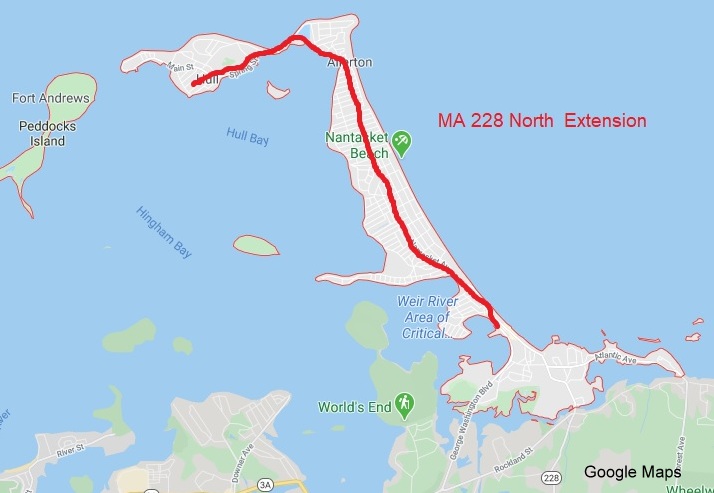
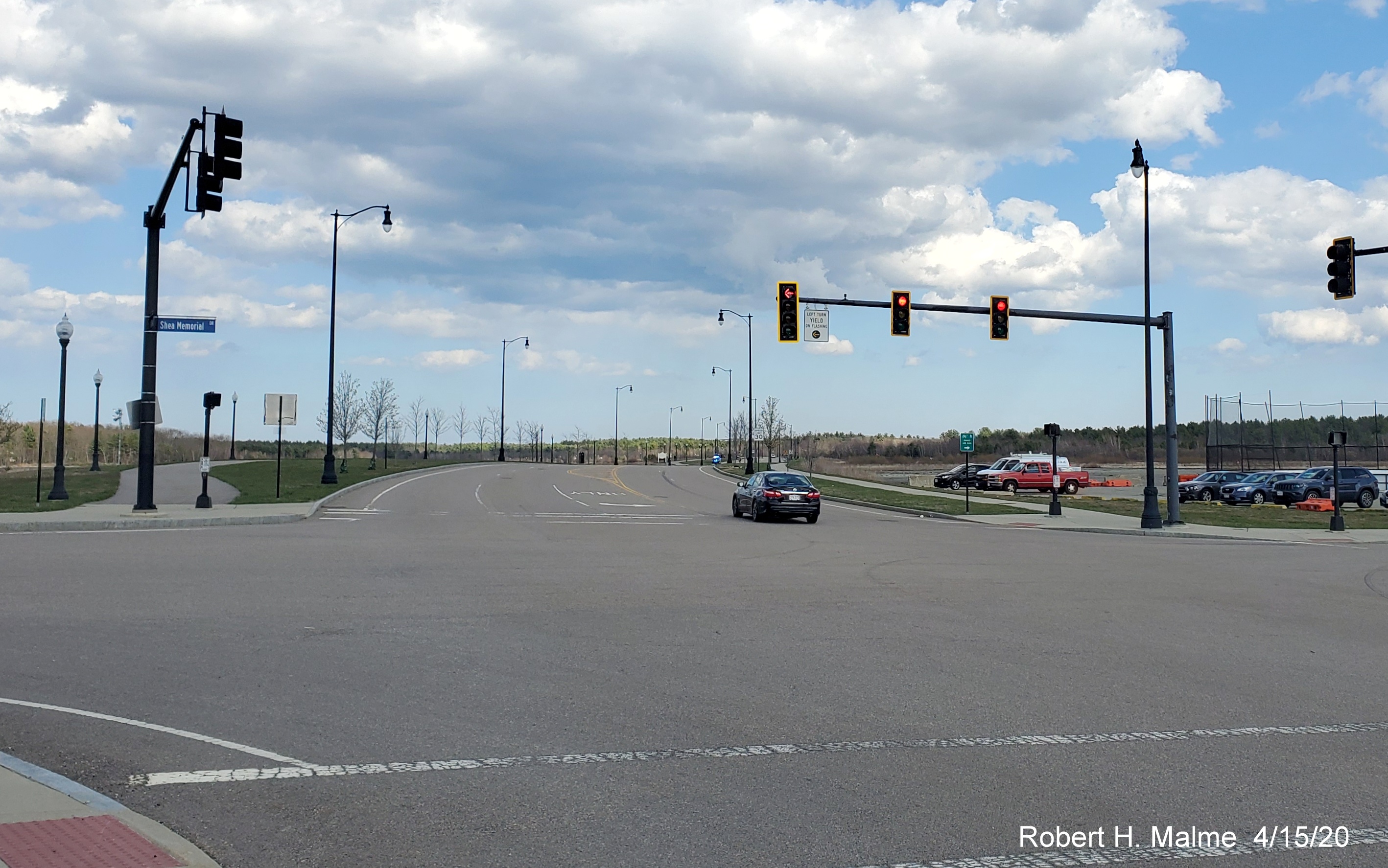
at the Pemberton Commuter Boat pier: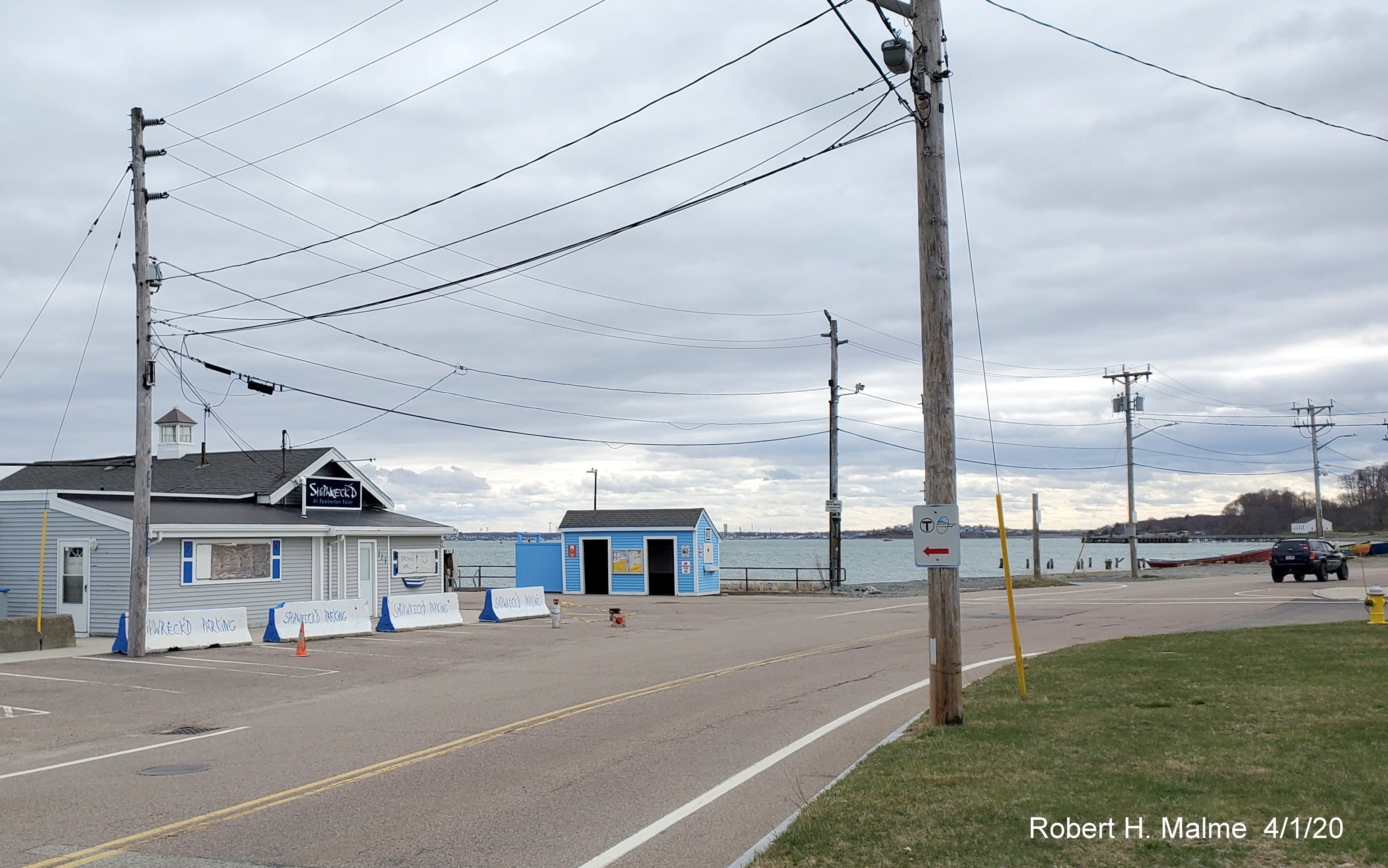 . Route would give traffic an alternate route to
South, provide a route address for businesses, and put commuter rail
station at intersection of 2 state routes. As part of the proposal, I
would raise the speed limit along Delahunt Parkway from its current 30
MPH to 45 MPH in the undeveloped portions of Union Point.
. Route would give traffic an alternate route to
South, provide a route address for businesses, and put commuter rail
station at intersection of 2 state routes. As part of the proposal, I
would raise the speed limit along Delahunt Parkway from its current 30
MPH to 45 MPH in the undeveloped portions of Union Point.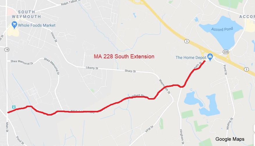
in Weymouth: