Improving
the Massachusetts Highway System
Suggestions
for New Routes
A. An
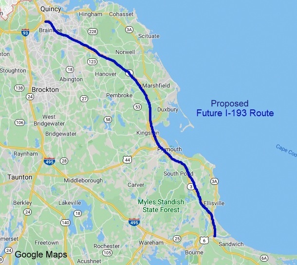
Interstate to Cape Cod from Boston (well, Braintree) , perhaps
Why? Interstate
routes should mark the most important transportation corridors in a
state. The most important route for tourists and commerce between
Boston, Plymouth and Cape Cod is currently a state route for its last
40+ miles. You can take an interstate from Providence to (almost) the
Cape, so why not from Boston? Also, Plymouth is celebrating its 400th
birthday in 2020, shouldn't there be an interstate to "America's
Hometown?"
How? By turning  into an
  spur route from Braintree to
  at the Sagamore Bridge, either or I-393. (Some dislike 193
because there is a state route
at the Sagamore Bridge, either or I-393. (Some dislike 193
because there is a state route  ,
but it's short (less than 3 miles) and along the Connecticut border, so
I don't think there would be any confusion of the two. Massachusetts
already has both
,
but it's short (less than 3 miles) and along the Connecticut border, so
I don't think there would be any confusion of the two. Massachusetts
already has both  and
and  .)
.)
The Map of the
Proposed Route:
This proposal
would entail moneys needed to upgrade parts of
to Interstate Standards, particularly bridges and ramps. The cost is
unknown. There have been at least 2 studies looking into the cost of
converting  to an Interstate, I know of no related study about upgrading .
The only segment that could probably be signed as an Interstate now is
from in
Braintree to
to an Interstate, I know of no related study about upgrading .
The only segment that could probably be signed as an Interstate now is
from in
Braintree to  in Weymouth. Perhaps much of the rest of the upgrade could be done
during the long planned proposal to widen
between Weymouth and Duxbury. Recently completed bridges carrying
in Norwell and Hanover were constructed for 3 lanes of traffic in each
direction.
in Weymouth. Perhaps much of the rest of the upgrade could be done
during the long planned proposal to widen
between Weymouth and Duxbury. Recently completed bridges carrying
in Norwell and Hanover were constructed for 3 lanes of traffic in each
direction.
Issues with other
Routes
What to do with  (or, in my view
  )? The easiest plan would be to
keep it where it is as a concurrent route. If, however, a decision was
made to eliminate south of Burlington or south of
its intersection with ,
a major problem would be what to do with
)? The easiest plan would be to
keep it where it is as a concurrent route. If, however, a decision was
made to eliminate south of Burlington or south of
its intersection with ,
a major problem would be what to do with  south of Boston. One option,
perhaps the easiest, would be simply to extend
south of Boston. One option,
perhaps the easiest, would be simply to extend  at its current ends north
over
between Quincy and Boston and south over from Kingston through
Plymouth. The rest of
could be renumbered, but to what? I would suggest a number close to 53,
perhaps a resurrected
at its current ends north
over
between Quincy and Boston and south over from Kingston through
Plymouth. The rest of
could be renumbered, but to what? I would suggest a number close to 53,
perhaps a resurrected  (now
(now  ) or the unused Route 54. Another
idea suggested via Facebook would be, at the southern end, replace
with
) or the unused Route 54. Another
idea suggested via Facebook would be, at the southern end, replace
with  ,
by extending that route from Kingston to Bourne.
,
by extending that route from Kingston to Bourne.
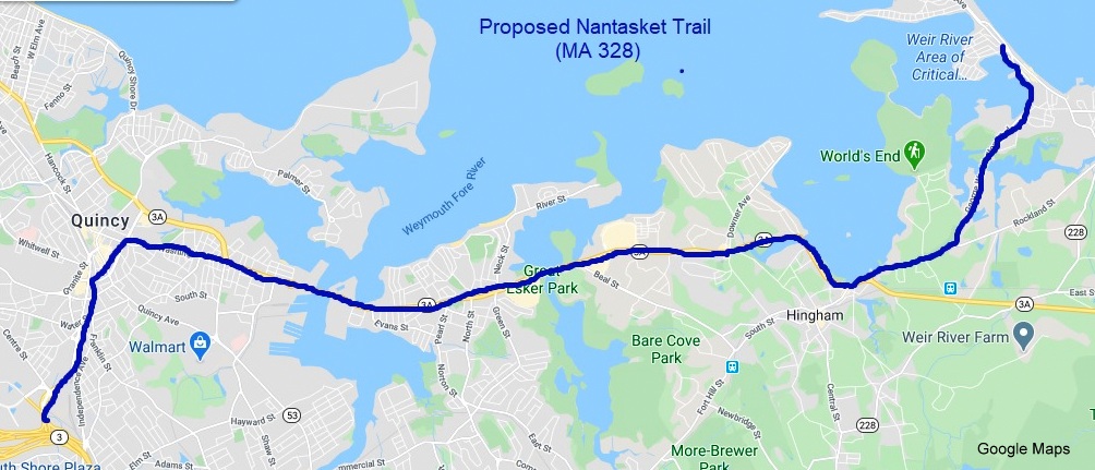
B. The 'Nantasket
Trail' or 
Why? Create a
more direct route from Braintree to Nantasket Beach using existing
mostly 4-lane routes, helping decrease traffic on mostly 2-lane  through Hingham which is a
legacy of the original
through Hingham which is a
legacy of the original  ,
and its proposed 1960s expressway routing. Help properly sign the
east-west portion of North-South MA 3A between Quincy and Hingham for
those directions.
,
and its proposed 1960s expressway routing. Help properly sign the
east-west portion of North-South MA 3A between Quincy and Hingham for
those directions.
How? Create a new
route that would start at Burgin Parkway extension exit from
in Braintree and continue along into Quincy until taking a right at
Hannon Parkway to Revere Road, a bypass route around Quincy Center, to
Washington Street (which was a state route,  , until 1959) where it would
turn east to the intersection with
/ Southern Artery where it would then run concurrently with from Quincy to Hingham,
continue along Summer Street, Rockland Street, and George Washington
Boulevard, state routes currently without a number, to end at Nantasket
Avenue ()
at Nantasket Beach.
, until 1959) where it would
turn east to the intersection with
/ Southern Artery where it would then run concurrently with from Quincy to Hingham,
continue along Summer Street, Rockland Street, and George Washington
Boulevard, state routes currently without a number, to end at Nantasket
Avenue ()
at Nantasket Beach.
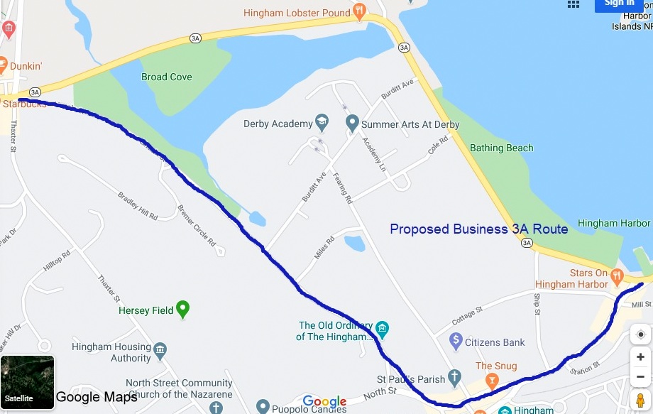
C. Business
Routes
Currently,
Massachusetts, like many of its neighboring states, has no business
routes. The existing route system is mostly designed to take traffic
away from commercial areas, not to encourage it. Many cities and towns,
however, could perhaps benefit from having an established route to take
potential customers to increasingly less trafficked business areas,
helping the local economy.
Idea: Create a
new set of Massachusetts Business Routes under a public/private
partnership arrangement. Those interested in establishing a business
route would provide money for studies, sign manufacturing, and
maintenance. MassDOT would provide and install the signs and coordinate
maintenance of the routes.
An Example. From
my hometown of Hingham, a proposed Business route serving the Hingham
Square area. The original coastal route to the Cape used the proposed
business route through Hingham Square until it was bypassed in the early
1920s, largely due to problems with traffic bound for Nantasket Beach.
Today, the area could probably use more traffic, both to businesses and
historic sites in the area:
D. Adoption of Milepost Based Numbers
Good news to
report on this suggestion, MassDOT announced in November 2019 that it
would change its sequential exit numbering system to that based on
highway mileage starting in late summer 2020. For more information
on this, visit my Massachusetts Interstate and US Route Exit page
or MassDOT's Exit Renumbering
Project website. While this change is long overdue, there
has been some criticism of some of the agency's exit renumbering plans.
I will detail them here and what I would suggest be done instead:
1.  /
/
MassDOT plans to
keep the current exit number practice of continuing  's exit numbers along
.
When plans for the first renumbering effort were publicized in 2015,
was given its own mileage based exits. MassDOT now thinks that this may
be too confusing and will continue counting the mileage from the
Connecticut border for exit numbers on . They are going to be placing
'dual mile markers' along that will list both the sum
mileage ('s)
and miles. MassDOT also says that this
may be a prelude to redesignating as an
extension, if this dual milepost system proves too difficult for drivers
to follow. I don't think the idea of two separate routes have two
different sets of exits is all that confusing. MassDOT also nixed the
idea of continuing the exit number mileage from other states
(Connecticut's for ,
Rhode Island for
's exit numbers along
.
When plans for the first renumbering effort were publicized in 2015,
was given its own mileage based exits. MassDOT now thinks that this may
be too confusing and will continue counting the mileage from the
Connecticut border for exit numbers on . They are going to be placing
'dual mile markers' along that will list both the sum
mileage ('s)
and miles. MassDOT also says that this
may be a prelude to redesignating as an
extension, if this dual milepost system proves too difficult for drivers
to follow. I don't think the idea of two separate routes have two
different sets of exits is all that confusing. MassDOT also nixed the
idea of continuing the exit number mileage from other states
(Connecticut's for ,
Rhode Island for  and ),
recommended under FHWA signing guidance, because they believe drivers
like to be notified that they have crossed state lines. Is not what
state Welcome signs are for? If MassDOT wants to change
to ,
their plan makes sense, else give it own set of numbers.
and ),
recommended under FHWA signing guidance, because they believe drivers
like to be notified that they have crossed state lines. Is not what
state Welcome signs are for? If MassDOT wants to change
to ,
their plan makes sense, else give it own set of numbers.
2.  Freeway
MassDOT plans to
continue the practice of counting 's
mileage as a continuation of 's, therefore the first exit number
in Burlington will be 72. If MassDOT would take up my suggestion of
making all of 'Route 3' ,
then this isn't a problem (potential mileage changes from my suggested
routings aside). Most Massachusetts drivers, however, see and
as two separate routes, and would be more informed by exit numbers
reflecting the mileage to or from  /
in Burlington. Therefore, regardless of whether is truncated to /,
give this route its own set of exit numbers starting in Burlington.
/
in Burlington. Therefore, regardless of whether is truncated to /,
give this route its own set of exit numbers starting in Burlington.
3.  on Cape Cod
MassDOT plans to
use 's
mileage from the RI border to number the Mid-Cape Highway exits, meaning
the exits would run from 55 to 88. This has led many on Cape Cod to
oppose the exit renumbering plan all together (it was opposition to exit
renumbering by Cape Cod that helped postpone the 2015 exit renumbering
project). MassDOT currently insists that despite opposition it is going
ahead on having the total
mileage numbers be used on the Cape, though they've made this the last
route to be renumbered. In communication with MassDOT, I and others have
suggested a possible compromise, renumber the exits, but use Mid-Cape
Highway mileage instead. Therefore current Exit 1 can stay Exit 1 and
drivers will know by the exit number how far they are from or to the
Sagamore Bridge (especially stuck in traffic on summer weekends). Though
MassDOT officials have stated they considered options like this, even
the idea of creating a concurrent route along the Mid-Cape Highway to
base exit numbers on, publicly they are still committed to the 's numbers at this time (May
2020).
4.  from Peabody to Gloucester
As pointed out on
the Route Change Suggestions's page, runs concurrently with from Canton to Peabody.
MassDOT plans to continue this mileage as the basis of Route
's exit numbers. This means the first exit number will be 37 and the
last 55. In addition, in an effort to avoid too many suffixed exits
(e.g. 1A, B, C), MassDOT has proposed exit numbers along
that at times are 2 miles off the actual mileage. For example, the  exit in Essex at Mile 45 is to be Exit 47 to avoid too many suffixed
exits in the Danvers stretch, impacting the benefit of using milepost
based exit numbers. As part of my suggested route changes,
should be truncated to Peabody. With or without that action, most
drivers would benefit knowing accurately how far they are from the first
interchange than from the Canton one on the south side of Boston and I
would suggest start the exit numbering in Peabody and assigning a few
suffixed exits in Danvers (see my suggested numbers on the Exit List).
exit in Essex at Mile 45 is to be Exit 47 to avoid too many suffixed
exits in the Danvers stretch, impacting the benefit of using milepost
based exit numbers. As part of my suggested route changes,
should be truncated to Peabody. With or without that action, most
drivers would benefit knowing accurately how far they are from the first
interchange than from the Canton one on the south side of Boston and I
would suggest start the exit numbering in Peabody and assigning a few
suffixed exits in Danvers (see my suggested numbers on the Exit List).
Have Comments, Suggestions on these or other routes feel free to E-mail me at
rmalme7374 at gmail.com.
(c) Robert H. Malme 2020