Where: From US 74/76 near NC 211 interchange
east of Whiteville, Columbus County to US 17 Shallotte Bypass, Brunswick County*
Length: Approx. 28 Miles
Needed: Construct New Interstate Standard Freeway
Construction to Start(?): After 2035
*or perhaps Wilmington
Segment Information
As currently proposed, Interstate 74 is to follow a new freeway
alignment from near the current NC 211 interchange with US 74/76
southeast to US 17 near Shallotte. This route toward South Carolina is
still not settled and has been the subject of many different ideas since
first proposed in 1997. NCDOT has even produced two different 'official'
routes, the currently favored proposal has been languishing since a
feasibility study about the route was released in December 2005.1
Since then several Wilmington officials have promoted the idea that the
interstate should end in that city (see section F, below) however, no
legislation needed for that to happen has been brought officially up by
state or federal officials whose approval would be needed to get funding.
A. THE ORIGINAL I-74 PROPOSAL
The first option studied by NCDOT since the 1990's, originally listed
as late as the 2006-2012 STIP as Project R-3436, would have built a new
31 mile freeway from US 74/76 near Whiteville to US 17 somewhere north
of the South Carolina border. While this is still the official route, changes have been made to how it is
listed and whether it has been funded over the years. The R-3436 project was later listed simply as a
'Feasibility Study Reevaluation in Progress' after a new routing
proposal from NC's Governor Easley in 2003 (see part B below).2
With the release of the feasibility study re-evaluation in August 2005
this older proposal is now seen simply as a basis of comparison to tout
the merits of the proposal discussed in section B. This was actually not
the first reevaluation of this route. In 2000, citing concerns that the
planned I-74 routing through Brunswick County could be environmentally
damaging, NCDOT undertook another feasibility study on the possibility
of upgrading US 74-76 to interstate standards from Whiteville to the
future US 17 bypass west of Wilmington (which NCDOT announced in Sept.
2002 would also designated as Interstate 140).3 The study was
completed in the Fall of 2001 and indicated it would be possible, at a
cost $4 million a mile, to upgrade the 40 miles of US 74-76 to an
Interstate.1 Some officials in Wilmington used this study as a basis
to call for the ending of I-74 in that city (See E below).6 The 2009-2015
STIP listed this as Project Number R-4462, unfunded, with an estimated construction cost of $160 million
and a start date after 2015.4The 2011-2015 STIP
had no entry, implying no construction until after 2023.5 All
STIP documents after 2015, up to the 2026-2035 STIP released in July
2025, have also not included a project to build I-74, meaning no new
construction is anticipated until at least 2036.
Sometimes parts of this proposed route have been tweaked. In
December 2018, as part of a new study of the proposed Carolina Bays
Parkway extension from South Carolina to US 17 in North Carolina, NCDOT
included the upgrade of US 17 north of the proposed extension to the
Shallotte Bypass, extending the length of the proposed highway by 10
miles (see I-74 Segment 20). This would
place the southern end of this segment near the current junction of NC
130 and US 17 and create a total length for I-74 from US 74/76 to US 17
at about 28 miles. However, the Bypass project became unfunded in 2023 and now
is not listed at all, meaning not work until after 2035. There was a project in the
Preliminary Quantitative scores list for the 2026-2035 STIP (despite it
already being in the 2024-2033 STIP) to upgrade the southern US 17
Business intersection along the US 17 Shallotte Bypass to an interchange
(U-6104), which would be useful if this became I-74, but the score is a
moderate 58.86/100.7 The current STIP, which also labels it a Future I-74 project,
does not have construction planned to start until 2031 (delayed from 2030 in the previous STIP).8
The 2026-2035 STIP list dropped an entry from the previous version that had a project for building I-74
to South Carolina, not from US 74/76, but SR 1300, Ash Little River Road in
Brunswick County, perhaps near its intersection with NC 904, this is only about 5 miles from the Hickman Road
intersection on US 17, one of the proposed sites for the Carolina Bays Parkway extension. The
entry description by the Grand Strand Area Transportation Study was: Enhance
mobility and connectivity for traffic moving in and through the project
area. Provides a more direct route for tourist and coastal truck traffic
traveling through the area. The cost is estimated at $39.7 million, but
would only be a small part of the construction needed to complete the
route to US 74/76. Perhaps this is why the Statewide Mobility score is
only 50.86.7 The 2026-2035 STIP had two new projects along US 17 also labeled at Future I-74, one
would upgrade the intersection on the Shallote Bypass with Smith Avenue to an interchange (U-5862) while the other
would build a temporary Reduced Conflict Intersection (RCI) on Business 17 north and south of Shalotte.8
Meanwhile, 6 projects in the 2023-2032 STIP that would help upgrade US 74/76 between NC 214 and Wilmington to
an interstate, which had suggested there may be support growing for that route (See Part F), disappeared from the
2026-2035 version.
B. ANOTHER PROPOSED ROUTE FOR I-74
On May 5, 2003 NC Governor Mike Easley announced, as part of his
'Strategic Transportation Plan' for SE North Carolina, a new proposed
routing for I-74 east of Whiteville, shown in map at the top of the
page. I-74 would not go to Wilmington, nor directly to SC, but would
instead travel east along US 74-76 to near Bolton and from there would
roughly parallel NC 211 to US 17 near Shallotte. I-74 would then follow
US 17 south to a few miles north of the SC border where it will jog
slightly west and then south on a new highway that would connect with an
extension of South Carolinas' Carolina Bays Parkway to Myrtle Beach
(currently SC 31).9 This route was referred to as Project
R-3436 in the 2009-2015 STIP, but was listed for 'planning and
environmental study' by the NC Turnpike Authority.10 (To see
a more detailed version of the map of this proposed routing created by
the NCDOT Statewide Planning Branch for the Strategic Highway Corridors
project, go to the NCDOT
site).11 NCDOT had previously announced helping SC
study extending the Parkway (which is currently 20 miles long with 6
lanes running from SC 9 to US 501) northward from SC 9 to the NC border.12,13
SCDOT was encouraged to petition the FHWA to have the Parkway be
designated I-74.14 The Governor's proposal directed NCDOT to
work with the FHWA to get approval for the proposed routes. If approved,
funding would be sought from Congress to help pay for them. It was never
clear how soon construction along the proposed route(s), if approved,
would begin, but it would not be for 20 to 30 years under the current
highway funding mechanisms.
NCDOT began studying the new proposal by holding public hearings on the
NC 211 routing in late 2003. The 2012-2018 STIP lists the project to
build an interchange along US 74-76 at NC 211 (Project R-61).17
The NC 211 interchange may now be east of where I-74 leaves US 74-76.
Construction of this interchange, along with one at US 74 and NC 242
(see I-74 Segment 17), began in 2010.18
A workshop was held by NCDOT at the Bolton Town Hall on July 10, 2006 to
provide information to interested citizens.19 The SAFETEA-LU
transportation law has moneys earmarked for both these projects. In
August 2005 an NCDOT financed feasibility study of the I-74 route in
this area was completed. The study was publicly released in December
2005, the cost pegged for the preferred alternative, a 64 mile stretch
mostly involving new freeway construction from Whiteville to the South
Carolina border using the NC 211 corridor and US 17, and the Carolina
Bays Parkway Extension (see I-74 Segment 20)
was $641 million.20
Under the Easley proposal this segment (and Segment 18) of I-74 would
would have been broken up 3 ways, with approximate mileage (some figures
taken from the I-74 Feasibility Study and NCDOT Strategic Corridors
website) being:
US 74/76 West of Whiteville to NC 211, Bolton Upgrade
Highway 22 Miles
NC 211 From US 74/76 to US 17 near
Shallotte (Mostly) Build Highway 28 Miles
US 17 Shallotte to Carolina Bays Parkway Extension
Build and Upgrade 12 Miles
Total Route: 62 Miles
A more extensive description of each section can be found at NCDOT's I-74
Study Site.
C. I-20 IN NORTH CAROLINA?
As part of Gov. Easley's 2003 proposal (see text and map link above),
US 74-76 from Whiteville to Wilmington would be upgraded to an
interstate, and be designated as part of an extension of I-20 from
Florence, SC to the Wilmington Outer Loop (I-140) (As of now there is no
proposal for I-20 to take over I-140's route to I-40, I-20 may continue,
however along US 74-76 to downtown Wilmington as shown on a Strategic
Highway Corridors map of the area). I-20 would total about 60 miles in
NC and I-74 and I-20 would be routed together for 22 miles from just
west of Whiteville to near Bolton. There does not appear to be much
support for this plan in South Carolina, however. On March 22, 2004 Rep.
Mike McIntyre held a series of "I-74/I-20 Rallies" in his district,
which includes Wilmington, to help jump start lobbying efforts for
building I-20. According to an article written that covered the event,
the I-20 proposal was losing steam due to SC's determined efforts to get
funds for I-73, a road that would parallel much of the proposed I-20
routing. An SCDOT spokesman is quoted in the same article as confirming
I-73 is the top priority and saying "(t)here are no plans or thoughts of
the I-20 extension."15 NCDOT at the SCDOT I-73 Summit in
February 2005 gave in on having I-20 be part of the discussions about
final routing for I-73 and I-74, allowing for an agreement on border
routings to occur, see I-74 Segment 19 and
I-73 Segment13.16 Though some
officials were still optimistic at the time.19 The SAFETEA-LU
transportation act signed by President Bush in August 2005 contained $5
million for NC to study extending the I-20 route to Wilmington. SC did
not request similar moneys, however. The subsequent Perdue
administration which held office from 2009 to early 2013 nor later
administrations have showed any enthusiasm for this proposal. Thus, as
it looks now, I-20 will not be routed east of Florence any time soon.
D. YET ANOTHER I-74 ROUTING PROPOSAL?
According to a March 10, 2005 article in the Whiteville (NC) News
Reporter, at a fundraising dinner for Congressman Mike McIntyre on March
7, NCDOT officials released a map showing I-74 routed through Columbus
County on a new route from US 74 east of Chadbourn to US 17 roughly
following the paths of NC 410 and 130 and crossing US 701 halfway
between Whiteville and Tabor City. This never appeared on the NCDOT
website. It is unclear whether this was new route was a fallback option
in case the NC 211 route proves unfeasible. A subsequent article a week
later in the same paper about progress on the NC 211 corridor study
implies this was the case.21 Both older proposals (the
original roughly following NC 904 and the suggested NC 211 route)
traverse swamp lands for most of their paths, the NC 410/130 route has
fewer wetlands to go through. The Nature Conservancy, which oversees
much of the Green Swamp through which NC 211, and the proposed I-74,
traverses came out publicly against the route soon after the proposal
was announced.22 They held had discussions with NCDOT about
possibly putting I-74 on a new alignment away from NC 211, which was
reflected in the subsequent I-74 feasibility study discussed above.23
There has been no subsequent news about this proposal through 2023.
E. BUILD I-74 AS A TOLL ROAD?
A November 16, 2005 report in the Wilmington Star-News indicated that
Brunswick County officials approached the North Carolina Turnpike
Authority about financing the proposed 44.8 mile I-74 segment from US
74/76 in Bolton to the SC Border as a toll highway during a meeting
earlier in the month. The officials, seeing both the $550 million
projected cost from feasibility studies and that NCDOT may not build the
road with current revenues for another 20-30 years, have suggested
building it as a toll road to speed up construction.24 At its
June 14, 2006 meeting the Turnpike Authority Board agreed to study
building I-74 as a toll road but only the Brunswick County portion that
will parallel US 17. They do not believe traffic counts along the NC 211
corridor portion would be high enough to make tolling that part
feasible. A preliminary feasibility study put the cost of building the
toll road 22 miles from US 17 in Supply to the SC border at $340
million.25 The consultants final report in June 2007
indicated that tolls would only cover 42% of the cost and would not be
worth building if the other connecting routes were not built first.
Substantial money would be required from the state legislature which
would compete with money needed for the nearby proposed Cape Fear Skyway
where tolls would cover only 55% of the cost.26 NCDOT,
however, released an updated Brunswick County transportation plan in
July 2008 which not only still included the proposed toll road but bowed
to local official's wishes to keep I-74 on a separate alignment and
extended it all the way from Shallote to the SC border. They also wanted
a connector route built between I-74 and I-140 and to upgrade US 17 to
an expressway.27 The exits along the proposed toll road would
be for NC 211, the I-74/I-140 connector, Royal Oak Road, NC 130, NC 904
and Hickman Road.28 There has been no news about the
proposal since then.
F. END I-74 IN WILMINGTON INSTEAD? [UPDATED 6/23/24]
Business and political leaders in the Wilmington area saw the
designation of I-140 in 2002 and NCDOT's US 74-76 feasibility study
(discussed above) as incentives to build Interstate 74 along US74/76 and
end it at I-140,
west of the city. "It's an excellent hook to pull I-74 east" according
to a statement at the time by Rep. Mike McIntyre (D-NC).3,4
With the proposed I-20 extension to Wilmington still only in the study
phase, US 74-76 planned to be upgraded to interstate standards, and the
apparent high costs (over $500 million) of routing an interstate through
wetlands, there may be renewed support to having I-74 simply end at the
port city. NCDOT seemingly doesn't rule this out in that the Feb. 2005
agreement with SCDOT has that state willing to build an extension of the
Carolina Bays Parkway to the NC state line 'to connect with either I-74
or a spur of I-74.'22 NCDOT's Strategic Highway Corridors
plan released in 2004 indicated that US 17 south of Wilmington to SC
would be upgraded to a freeway (though recent reports have NCDOT
suggesting cost considerations may mean it would be upgraded slowly over
several decades, with stoplights being planned for some intersections in
the interim). This freeway could conceivably be an I-74 spur (or could
simply be an extension of I-140, but plans are now to route that from US
17 east onto the proposed Cape Fear Skyway). It is unknown though when
work on upgrading US 17 is planned. NCDOT seemed to be hedging its bets
towards a Wilmington terminus in the summer of 2012 when they replaced
US 74 mile markers from NC 41 near Lumberton to east to Delco to I-74
mileposts (the last being at mile 271). They even posted an I-74 Exit
number for the NC 87 North ramp of of US 74/76 West in Delco, Exit 270
(see the photo below). These mile markers run about 12 miles further
east than where I-74 would turn south under its current routing
proposal. The mile markers are the cheapest available, coming without
I-74 shields, probably in case they need to be taken down again.28
In May 2016, NCDOT released its preliminary list of 2018-2027 STIP
projects. The list contained 13 projects along US 74/76 to either
upgrade the route to interstate standards or upgrade intersections to
interchanges. Eight of these projects were on US 74/76 east of where the
official route of I-74 would leave to the southeast. Meanwhile, there
were no listed projects, other than building the Carolina Bays Parkway
Extension (see I-74 Segment 19), along the
official route from Whiteville to South Carolina in subsequent STIPs
through 2022.30 It would appear that even NCDOT appears to
favor I-74 going to Wilmington. Only time will tell whether this means a
true shift in I-74's official route.
On February 24, 2017 NCDOT posted a News Release regarding an upcoming
project along 8 miles of US 74/76 between NC 140 (Future I-140) and
Pineland Road just east of Delco. The news release indicated US 74/76
would be widened to make it safer and provide a better route for
commercial vehicles. The news release is prefaced with the comment:
"Work to Upgrade the Road to Interstate Standards."28 US
74/76 in this area is not currently a freeway and would need more than
widening to be able to sign it as an interstate, but it shows that NCDOT
is moving toward making the route interstate ready, and that a possible
interstate route for the corridor could be Interstate 74.
On October 30, 2017 an article appeared in the Wilmington Star-News
reporting that Wilmington officials were not only pushing for I-74 to
end in Wilmington, but that they wanted to sign it along I-140 from the
soon to be completed interchange with US 74-76 north and east to US 17
at Scotts Hill creating a 57-mile long interstate route from Whiteville.30
The idea has the support of both the NCDOT Division 8 Engineer
and the Wilmington Metropolitan Planning Organization (MPO) along with
commissioners from both Brunswick and New Hanover counties. The MPO
spokesman said their next step would be to ask NCDOT for a future
interstate designation along US 74/76. There has been no indication
since that time that NCDOT is considering this plan, however a project
to upgrade US 74/76 to Interstate standards has appeared in the latest
list of potentially funded future projects published in May 2024.
NEW-Here is the list of potential 2026-2035 STIP Projects east of the
official I-74 Route (between NC 211 and Mt. Misery Road in Wilmington)
that would upgrade the highway to Interstate Standards, possibly for
I-74, from west to east:31
Route
Project Number
From
/ Cross Street
To
/ Cross Street:
Cost
(M$)
Project:
US
74 , US 76
R-4462
NC 214 (Sam Potts Highway)
--
20.5
Construct Interchange
US
74 , US 76
R-4462
West of SR 1844 (Oscar Blanks
Rd)
East of Columbus/Brunswick County
Line
85.4
Construct Interstate Standard Bypass
of Delco
US
74 , US 76
R-4462
East
of Columbus/Brunswick County Line
East
of NC 87 (Maco Road)
265.0
Upgrade
Roadway to Interstate Standards
US
74 , US 76
R-4462
East
of NC 87 (Maco Road)
SR
1426 (Mount Misery Road)
68.3
Upgrade
Roadway to Interstate Standards
US
74 , US 76
R-4462
SR
1800 (Blacksmith Road)
--
9.0
Upgrade
Intersection to Interchange
The
final projects chosen will be listed in the Draft 2026-2035 STIP to
be released in early 2025.
Segment Video
Tour I-74's possible route along US 74/76
in Brunswick and Columbus Counties in This
Video courtesy of J. Austin Carter, from January 2013.
Segment Photos (Hover over for larger image)
Exit
sign at the NC 130 interchange on US 17 near Shallotte which, under some
alternative corridors for the proposed routing above, will be an exit
off of I-74. Photo courtesy of Adam Prince.
Some photos taken along possible alignments of I-74, these from Google
Maps Street View, dates listed in photos:
Mileage
sign after end of US 74/76 freeway at NC 211 exit in Supply. If I-74 is
extended to Wilmington, only 29 miles to go.
The
first intersection encountered after NC 211 is at I-74 mile marker 260.
This would have to be removed if this were to become interstate
standard.
The gore sign with I-74 mile based
exit that stood at the NC 87 intersection in Delco until 2019 (image
from January 2017). This would have to be removed if this were to become
interstate standard.
The Mile 270 marker still standing
after the NC 87 intersection in Delco.
Comment: Given the news that the latest proposal to toll I-74 in
Brunswick County is economically unfeasible, probably no longer how
long it is, and that a route through the Green Swamp would be
environmentally and economically costly, might it make more sense to
fund the upgrading of US 74-76 to interstate standards and route I-74
along it in its entirety to end at Wilmington then perhaps extend the
proposed toll road further north paralleling US 17 to tie into I-140
when it's completed? The toll road could be an I-74 spur route.
If anyone has any other photos or information to share about or near
this segment, feel free to E-mail
me
 Segment 19
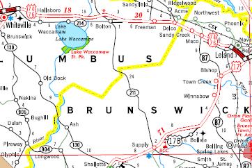
 I-20 IN NORTH CAROLINA?
 YET ANOTHER I-74 ROUTING PROPOSAL?
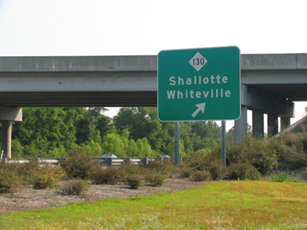 Exit
sign at the NC 130 interchange on US 17 near Shallotte which, under some
alternative corridors for the proposed routing above, will be an exit
off of I-74. Photo courtesy of Adam Prince.
Exit
sign at the NC 130 interchange on US 17 near Shallotte which, under some
alternative corridors for the proposed routing above, will be an exit
off of I-74. Photo courtesy of Adam Prince.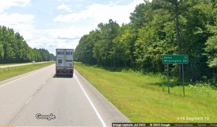 Mileage
sign after end of US 74/76 freeway at NC 211 exit in Supply. If I-74 is
extended to Wilmington, only 29 miles to go.
Mileage
sign after end of US 74/76 freeway at NC 211 exit in Supply. If I-74 is
extended to Wilmington, only 29 miles to go.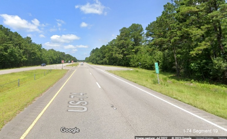 The
first intersection encountered after NC 211 is at I-74 mile marker 260.
This would have to be removed if this were to become interstate
standard.
The
first intersection encountered after NC 211 is at I-74 mile marker 260.
This would have to be removed if this were to become interstate
standard.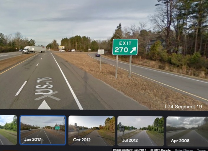 The gore sign with I-74 mile based
exit that stood at the NC 87 intersection in Delco until 2019 (image
from January 2017). This would have to be removed if this were to become
interstate standard.
The gore sign with I-74 mile based
exit that stood at the NC 87 intersection in Delco until 2019 (image
from January 2017). This would have to be removed if this were to become
interstate standard.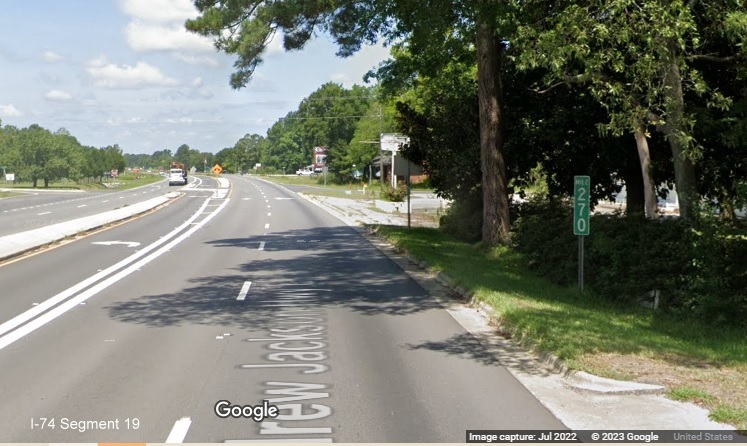 The Mile 270 marker still standing
after the NC 87 intersection in Delco.
The Mile 270 marker still standing
after the NC 87 intersection in Delco.